ECUADOR
Ecuador is a small country but beautiful by their four regions
The Highlanda beautiful for its lakes and mountains
The Coast beautiful for its beaches and its people
The Amazon extraordinary for its forests and ethnic groups
The Galapagos Islands magnificent its species only ones
The Coast beautiful for its beaches and its people
The Amazon extraordinary for its forests and ethnic groups
The Galapagos Islands magnificent its species only ones
 |
HIGHLAND REGION
GUARANDA
Province: Bolivar
Guaranda has beautiful places of singular beauty and attractions, it is surrounded by hills San Jacinto, Loma de Guaranda, San Bartolo, Cruzloma, Tililac, Talalac and Mirador. It is known as the City of Seven Hills.
Guaranda, is the smallest capital of the provinces of the Sierra.
the tourist can participate in different Party as: the "Carnival of Guaranda" which is one of the most famous of Ecuador. The city is full of warmth, is played with streamers, flowers, candy, lotions and adorn the balconies of the houses, especially during the Carnival days.
 |
| CARNAVAL "GUARANDA" |
Tiagua Cave
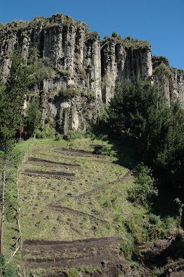 |
| Tiaguas cave |
Two mountains, with interesting formations due to surface erosion process. Access to phenomenological creations easily ascend the two mountains where begins the formation of caves. They are located south of Salinas.
You can go through the valley within two blocks of rock, and you see a beautiful landscape and the sides of the rocky walls caves can be seen above, the valley also runs a small stream to which this advantage for him provision of drinking water in the community of Salinas.
In the caves also you can Found archaeological remains belonging to Valdivia culture.
El Chimborazo Reserve
 |
| Chimborazo |
It is a protected area in height, consisting mainly of moorland. Here you can see Chimborazo Volcano, the highest mountain in Ecuador, fully adorned with immense glaciers, and its neighbor, the Carihuairazo, both located in the heart of the area.
Through these walks can also visit sites like Temple Machay, instead of offering to ancestral Chimborazo, La Chorrera, a large canyon where the river of the same name that also exhibits a unique landscape composed of large rocks, and any sharp vertical cuts of up to 100 m high.
TUNGURAHUA
 |
| Gateway to the Amazon |
Baños de Agua Santa, a small town lying between the central Andes and the Amazon Region of Ecuador, is located eight kilometres from the crater of the Tungurahua Volcano and 30 minutes from Ambato.
AMBATO
 |
| Ambato |
The markets of San Juan de Ambato, known as the Garden of Ecuador, are full of glistening fresh flowers and fruits that flourish all year round on the local farms, favoured by good weather and rich volcanic soil.
Tungurahua Volcano

Rising 5,023 m. and with a 400-metre diameter crater, the Tungurahua Volcano has been erupting since 1999. The volcano, located 33 kilometres from Ambato and on the outskirts of the tourist town of Baños, provides a nocturnal display of explosions and incandescent rocks that disgorge from its crater.
COTOPAXI
 |
| National Park Llanganates |
Conceal the Incas' lost treasure, perhaps because it is one of the world's few untouched paradises where life can be seen in all its exuberance. Covering 219,707 hectares spread over the provinces of Tungurahua, Cotopaxi,Pastaza and Napo, it is the source of the Napo and Pastaza rivers. More than 200 lagoons have been cataloguedwithin the park's lake area, considered one of the world's most significant wetlands and where temperatures fluctuate between 3°C and 24°C.
 |
| Cotopaxi National Park |
Although buffeted by arelentless wind and embraced an all-encompassing silence, the Cotopaxi National Park thrives with life and energy. Created in 1975 and straddling the provinces of Pichincha, Cotopaxi, and Napo, the park is located 60 kilometres from Quito and 30 kilometres from Latacunga.
 |
| Quilotoa Lake |
Quilotoa is the westernmost volcano in the Ecuadorian Andes and within whose crater a nine-kilometre wide caldera has formed, believed to have been caused by the collapse of the volcano about 800 years ago. According to various studies, the resulting volcanic lava flowreached the Pacific Ocean. The 250 metre-deep caldera is now filled by a lagoon whose minerals lendthe surface a greenish-blue tinge when caught by the sunlight. Seen from the shores, the springs deep within appear as a stream of bubbles as they rise to the surface
PICHINCHA
 |
| Panecillo |
At 3,000 m. above sea level, the Virgin of Quito, based on the sculpture by Bernardo de Legarda, stands on the top of Panecillo hill in the centre-south of Quito. This replica, made by Agustín de la Herrán Matorral in 1976, is composed of approximately 7,000 pieces of aluminium and is also known as the Virgin of the Apocalypse in view of the symbolic elements included in the sculpture.
 |
| Mitad del Mundo |
At 45 minutes from Quito, the parish of San Antonio is home to a tall pyramid-shaped monument marking latitude 0°0'0" and a small town crossed by a line on the ground representing the equator. Here you can put your feet in two hemispheres at the same time, north and south.
 |
| San Francisco Museum |
San Francisco monastery hides behind its walls the religious life, art and architecture of colonial Quito. An imposing wooden door opens into the first colonial-style courtyard, flanked by high, wide-bodied columns and rounded arches. This is the first of the seven cloisters comprising the monastery that was built in 1535, a few months after the Spanish foundation of the city.
COSTA REGION
 |
| Santa Lucía de Las Peñas |
Santa Lucía de Las Peñas is a large beach backed by cliffs with dry forest vegetation and a wall of red mangroves lining the mouth of the Estero Roto inlet. At the end of this long stretch of sand, the sea washes into caves hollowed out in the cliff face. This beach is 286 kilometres away from Quito, on the coast of Esmeraldas province and very close to the Colombian border.
 |
| Mompique |
A long fringe of tropical rainforest is the backdrop to this quiet fishing village in the south of Esmeraldas province. For years Mompiche was hidden to visitors but its waves, which can reach heights of three metres, have not gone unnoticed by surfing groups.
 |
| Atacames Beaches |
The Atacames coast in the province of Esmeraldas is the favourite destination for travellers. The close proximity of its four beaches means that visitors can enjoy in a single day a crab ceviche in Tonsupa, a boat ride off the quiet village of Súa, sunset in Same and the nightlife on Atacames beach.
 |
| Guayaquil City |
Now a major trading centre, Guayaquil is the financial, political, cultural and entertainment hub of the area and one of the largest ports in the region.
 |
| Malecón Simón Bolívar o Malecón 2000 |
The banks of the river Guayas in the centre of the hectic city of Guayaquil are adorned with the Simón Bolívar Boardwalk. This architectural feature two and a half kilometres long is the prime emblem of the modern city and the favourite public recreational space for both Guayaquileños and visitors.
AMAZON REGION
Located in the eastern part of the provinces of Orellana and Pastaza, Yasuní National Park is the largest protected area of mainland Ecuador. It covers 982,000 hectares of tropical rainforest in the most biodiverse region of the Ecuadorian Amazon. The hot, humid jungles of Yasuní awaken the senses and fill with emotion anyone who comes here, to the most biodiverse corner of the planet. The geological history of Yasuní situates it in the lower Andes and in the higher areas. of theAmazon. Its hills encourage thousands of life forms to flourish in a rainforest that is occasionally flooded

 |
| Yasuni |
 |
| Tena |
By the valley of the River Misahuallí, in the south of the province of Napo in the heart of the Ecuadorian Amazon, is the town of San Juan de los dos Ríos de Tena. Its climate is hot and humid, with an average temperature of 25°C
 |
| Carlos Julio Arosemena Tola |
This canton is in the south of the province of Napo and has various natural attractions popular with visitors, in particular the famed mountains of the Cordillera de los Llanganates and the River Anzu. Gold panning is done by some of the local population, as this prized metal is constantly found in the river.
 |
| Asawanchu |
Eight kilometres from the town of Arajuno, Asawanchu community tourism centre stretches out in a jungle clearing, where a series of cabins have been built, mixing the typical Quichua housing with certain mod cons.
 |
| Chunda Pakcha |
Within the traditions of the Quichua people, the community of Chunda Pakcha de San José de Wapuno has maintained its cosmovision and its lifestyle and is happy to share its way of living with visitors. The conservation of nature, along with hunting and gathering, are the main daily activities, which tourists looking for a renewing experience can join in.
 |
| Antisana Ecological Reserve |
Not far from the town of Pintag the cold paramo of the province of Napo begins. The Antisana Ecological Reserve is located about 45 kilometres south-east of Quito and shelters 120,000 hectares of territory extending from the perpetual snows of Antisana at 5,758 metres down to the Cosanga region at 1,200 metres. The reserve is bordered by the Cayambe-Coca and Sumaco-Napo-Galeras national parks. These three areas comprise the most important conservation massifwithin the mountainous zones of Ecuador.
 |
| Podocarpus National Park |
The park spans 146,280 km² and crosses the basins of the rivers Nangaritza, Numbala and Loyola. Approximately 85% of the parkland is in the province of Zamora Chinchipe and 15% in Loja.
GALAPAGOS ISLANDS
The history of the village of Puerto Villamil on Isabela Island is linked to a past of exile and isolation. Puerto Villamil was previously a United States military outpost, as support for the base on the island of Baltra during the Second World War. In 1946, the Ecuadorian government regained control of the facilities and set up a prison for for the confinement of dangerous inmates.

 |
| San Cristobal Island |
San Cristobal is the easternmost island of the Galapagos archipelago, and also the oldest. On its western shore is Port Baquerizo Moreno, the most populous area on the island and the capital of the province. San Cristobal is also known for its beaches, which are densely populated by Galapagos sea lions, especially in the area of La Loberia.
Isabela, located on the western side of the Galapagos, is not only the archipelago's largest island but it also has the most varied ecosystem. At the southern tip of the island is the village of Puerto Villamil from where land and sea trips exploring the natural wealth of the Galapagos embark.
 |
| Isabela Island |
 |
| Isabela Island |
The history of the village of Puerto Villamil on Isabela Island is linked to a past of exile and isolation. Puerto Villamil was previously a United States military outpost, as support for the base on the island of Baltra during the Second World War. In 1946, the Ecuadorian government regained control of the facilities and set up a prison for for the confinement of dangerous inmates.
 |
SPORTS
 |
GASTRONOMY

ETHNIC GROUPS
ETHNIC GROUPS
 |
 |
 |
 |
 |